Aoraki is this mountain’s Māori name (Mt. Cook in English). Aoraki is the highest mountain in New Zealand at 3,724 metres (12,218 feet) one of 17 peaks exceeding 3,000 m in height. The Southern Alps, including Aoraki, extend nearly the length of the South Island. Including all peaks greater in elevation than 900 meters (3,000 ft), the Southern Alps comprise a total of 2,122 mountains.


In the Māori creation story, Aoraki was the eldest of the four sons of Rakinui, the Sky Father. Along with his brothers, Aoraki left the heavens in a canoe (waka) to visit Papatūānuku, the Earth Mother. When the brothers failed to return home the waka became the South Island (in Māori – Te Waka o Aoraki – The Canoe of Aoraki). Aoraki and his brothers turned to stone and became the first mountains in New Zealand.

Our day began at the Park Centre. It provided a wealth of information, including the fact that Sir Edmund Hillary used Aoraki as the training ground for his conquest of Mount Everest.

This art represents the brothers and the mountains with their names. Aoraki is in the centre. Rakirua and Rarakiroa are on the left and Rakiroa is on the far right. Towhirimatea, the wind, is between Aoraki and Rakiroa.
Tasman Lake

Tasman Lake formed since 1973 by the retreat of the Tasman Glacier. Until 1973 the Tasman glacier filled this valley up to the lower limit of the treeline visible along both sides of the lake. In 1973 the location this photo was taken from was 30 m below the surface of the glacier. The Tasman Glacier was reportedly constant in size for the first 2/3 of the 20th century.
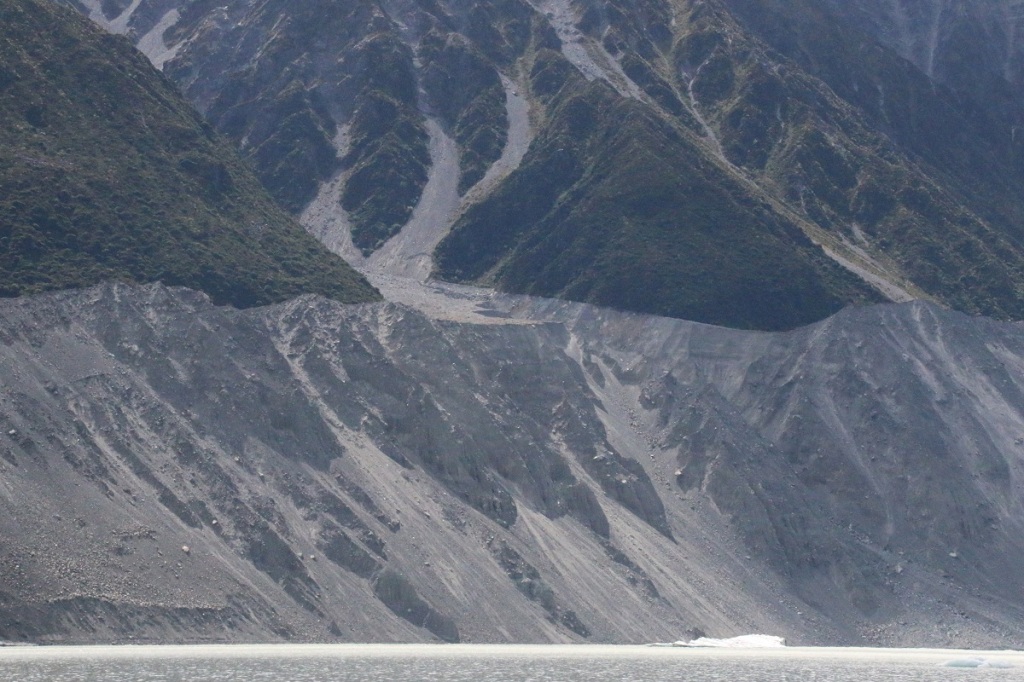
This photo shows a closer view of the left side of the lake looking towards the head of the lake. While there is no reference point to give scale, 30 metres is about the height of a 10-storey building.
Recession of the glacier was slow until the early 1990s when the current period of rapid retreat began. For the first two decades the retreat was at a rate about 280 m per year. More recently the rate has been estimated at between 450 and 800 m/yr.
The video below presents a slideshow of images from Google Earth. It’s timing is based on the sequence of years with new satellite photos of the area. These years are 1990, 2001, 2003, 2005, 2007, 2009, 2011, 2013, 2015, 2018 and 2020. This sequence starts in 1990 since there were no photos available for earlier years. As stated above, Tasman Glacier was reported to have remained relatively unchanged through the 20th century up to 1973, and the rate of change was reportedly slow until the 1990s.
You will see relatively little change between the 1990 and 2001 slides. After 2001, change is more rapid. I started looking at the formation of Tasman Lake only. I rapidly realized that there were three other lakes formed nearby in the same timeframe so I expanded the scale to include those lakes as well.
When you click on play it gives the option to go to full screen on the video. You need to do this to see the full frame, including the years in the top right. Points of interest in the video are:
– Tasman Lake in the middle left,
– two smaller lakes forming in the top left,
– a third smaller lake forming in the bottom right,
– Tasman glacier to the right of Tasman Lake, covered in charcoal gray slate rock for most of it’s length and with white ice showing at the far right. The glacier’s rate of flow is quite evident in the shapes of it’s rock-covered surface.
There is a lot going on in this video. You may need to watch it through a few times to capture it all. Click on this video and view it at full screen. Hit screen reduce to return to this website.
The rate of retreat of the Tasman glacier is amazing. Current predictions estimate that the entire glacier could disappear with two to three decades. Geological events of this nature normally occur over many human lifespans. This is predicted to be completed in less than one!
I cannot imagine a more graphic demonstration of global warming. The formation of a new lake is a geological event. This video documents the formation of four new lakes in two decades.
Climate change deniers; put that in your pipe and smoke it!

Returning to Tasman Lake, this photo shows the face of the glacier. Note that the treeline on the left is 30 metres above the water. By comparison, the face of the glacier appears to be a few to about 10 m high at most. For several kilometers above the lake, the glacier is almost gone already.
For safety reasons, we were unable to get close to the glacier. Parts of the glacier extend out under the water. If calving occurred under a boat, the results could be very dangerous. A 1.5 km safety buffer is therefore observed.

This is a wide-angle view of the glacier edge from outside the safety buffer. The shot below is a zoom on the centre of this photo.
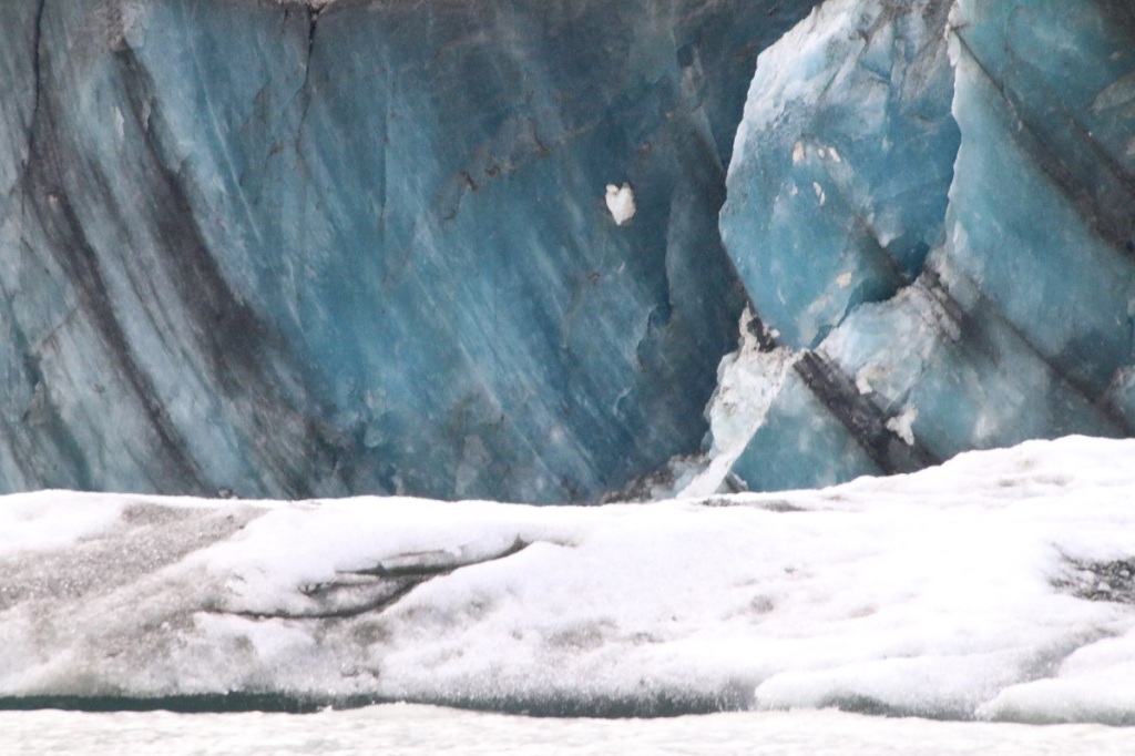
Beautiful but dangerous, viewed up close through the magic of a telephoto lens. I had to be selective to capture this ice edge. As is evident from the photo above, even the lead edge of the glacier is mostly covered in grey rocks.

While we weren’t able to approach the glacier face, we were able to approach the icebergs, and to pick ice cubes from them.
Oh for a glass of single malt!

Here are the happy campers with the glacier in the background.

Our tour guide was from the nearby village of Arrowtown. She had a Bachelor’s degree in Marine Biology and gave a very informative tour.
Note the beautiful New Zealand sky in the background.
There were several boats and several tour guides. In getting us all organized and aboard the boats, there was a high level of professionalism. This was a very good and well organized tour.

We returned to Glentanner and had a pleasant evening with new friends from Australia. We settled in for a good nights sleep fully expecting another great day of touring in the morning. I was awakened at 6:30 AM by an extremely heavy downpour. Raindrops were hitting the ground so hard that water was splashing 25 cm in the air. Since the van had no awning and the sliding door was only inches from the edge of the bed, there was no way to pack ourselves up in the campsite without getting the bed and bedding soaking wet!

I got very wet disconnecting the electrical and we headed for the only nearby cover, the entrance to the Glentanner Reception area. It looked a whole lot different from this in the rainstorm!.
We got our selves packed up and hit the road. The question now was where to? The plans for the day included hiking and star-gazing. That obviously wasn’t happening!
